|
|


Editorial
|
Press Releases
|
Book Reviews
|
Fragments
Serpent Mound I
|
Giants I
|
Osiria I
Register
for our new Hall of Records Newsletter!
Questions? Comments? Suggestions? Advertising? Press Releases?
Contact us!
Malta
|
Axum
|
Nabta Playa
|
Sea Serpent Sightings
|
Books
|
Video

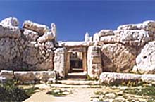
Hagar Qim, one of the more spectacular megalithic temples that dot Malta and the nearby island of Gozo. Hagar Qim,
Though not the oldest, is one of the best preserved temple structures to be found on the islands, where several statues
of the famous
"fat lady"
were discovered when the site was excavated around 1850.
Image from
The OTS Foundation.
|
|
Malta, located in the center of the Mediterranean Sea some 80 miles south of Sicily, is perhaps the most
historically rich country on Earth. A tiny island only 14 miles long by 8 miles wide, Malta has over a dozen major
archaeological sites and a colorful history stretching back many thousands of years, making it the most historically rich
country on the planet. Moreover, Malta's ruins are considered to be the oldest on Earth, believed to date as far back as
3500 b.c. or even older — much older.
Probably the most well-known ruins are those of
Hagar Qim
(above), which are also the best preserved. Hagar Qim, lit.,
"erect stones", is made up of several chambers, including an "oracle room", and several altars. It was there that
nineteenth-century archaeologists found the now famous "fat lady" statues, an ancient fertility figure more commonly known
as "the Venus of Malta". Based upon this and other discoveries about the religious nature of the monument, it is believed
that Malta lay at the center of an ancient matriarchal civilization that worshipped a mother goddess.
Hagar Qim and the
other structures were in fact temples where this mother goddess — who was essentially an embodiment of the fertility
of the land — was worshipped. Moreover, the still-visible ruts of the numerous ancient tracks created by countless
carts criss-cross the entire island, some of which are nearly two feet deep. The quantity of tracks on the island makes it
clear that the temples once lay at the center of a vast agrarian empire — much larger than the current island of Malta.
The numerous cart ruts point to massive amounts of produce being carted into the area from surrounding regions, which makes
sense as the temple in ancient times was, besides being
the center of religious belief, also the center of commerce. Interestingly, the tracks do not end at the edge of the cliffs
that overlook Malta's many beaches, but continue on for some distance into the surrounding ocean.
Though Hagar Qim is perhaps the most famous and well-preserved of the monuments, the oldest and largest is likely
Ggantija
on the nearby island of Gozo. Ggantija, lit., "belonging to the giants", was so named by the Maltese because they
believed the huge, megalithic stones used to build the monument could only have been lifted by giants. Some of the walls
are as much as 18 feet tall, and very thick, and contain niches and shrines which make it clear that Ggantija, like Hagar
Qim was also once a temple. Interestingly, the Maltese do have a tradition of giants on the islands, particularly Gozo. One
story,
"The Giantess of Qala",
talks about a giant woman who lived on the island of Gozo who was able to lift and carry around very heavy rocks. The story
appears to describe how some of the monuments were built, though the story might simply be a fabrication created by
imaginative islanders to explain the giant "fat lady" statues and the huge rocks that are literally all over the island.
As was discussed in last year's series on
Atlantis,
some believe that the Mediterranean Sea was once a vast, fertile plain which was destroyed by the same Great Flood that had
destroyed Atlantis. All that was left were the very highest places on the mountains, of which Malta and Gozo are some of
the few remaining. Their central location and the existence of so many different temples in one place supports the theory
that Malta was once the center of a vast empire known as
Osiria,
which we will discuss later in this issue.
Malta is a well-ordered, small island country full of quality restaurants, shopping and lodging facilities, and even its own
international airport, making it a favorite European tourist destination. Malta also has a rich history, having once been
owned by
crusading knights
who had actually purchased the island for their own use. Sitting at the crossroads of the Mediterranean,
Malta is an excellent tourist destination that may preside over an ancient secret. Learn more about Malta in
part one
of our series on the ancient empire of Osiria.


MaltaVista
The Megalithic Temples of Malta
The Megalithic Temples of Malta: Map
OTS Foundation: The Temples of Malta
Hagar Qim Temples
The Megalithic Temples of the Maltese Islands: Hagar Qim Temple
- Ggantija Temple
Hospitallers of St. John of Jerusalem
Lonely Planet: Malta
Sydney Morning Herald: Malta
EuroTravelling.net: Malta
VisitMalta.com
VisitMalta.com: How to Get There
Malta Direct Travel
Maltours
SelectMalta.com
Pilgrim Tours: Malta
0800 Malta
Budget Travel: Malta
Columbus World Travel Guide: Malta
Travel Malta
Dream Malta
Le Meridien Phoenicia
U.S. State Dept.: Malta Travel Info
|
|
|
|

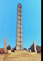 An ancient obelisk in Axum, Ethiopia. At 70 feet it is the tallest remaining of a group of seven. All seven obelisks
were decorated identically, with astral imagery at the top, and sacrificial
altars at the bottom, indicating that these obelisks were once used for astral worship. This particular obelisk is topped with an
image of the sun. Image from
EthiopiaTravel.com.
An ancient obelisk in Axum, Ethiopia. At 70 feet it is the tallest remaining of a group of seven. All seven obelisks
were decorated identically, with astral imagery at the top, and sacrificial
altars at the bottom, indicating that these obelisks were once used for astral worship. This particular obelisk is topped with an
image of the sun. Image from
EthiopiaTravel.com.
|
|
Far to the north of Addis Ababa, the modern capitol of Ethiopia, is Axum, the ancient political and religious capital
of Ethiopia. Though the exact date of its founding is not known, what is known is that the Queen of Sheba, who reigned
around 1000 b.c., had Axum as her royal capital.
Though Axum is no longer the civil capitol of Ethiopia, it is still the center of religious activity, being
the location of the beautiful St Mary of Zion's church and, it is rumored, the
Lost Ark of the Covenant. And the story of how the ark came to be in Axum is fascinating.
The story goes, the Queen of Sheba, hearing of King Solomon's great wisdom and glory, traveled from Ethiopia to visit him,
bringing with her a large tribute of gold and spices
( 1 Kings 10:1-14 ).
While there, according to the biblical account, she was greatly amazed by his wealth and splendour, which in her eyes
surpassed even the amazing reports she had heard. Interestingly, near the end of the biblical account, Solomon rewarded Sheba
with similar gifts, and more: "And King Solomon gave unto the queen of Sheba all her desire, whatsoever she asked, beside that
which Solomon gave her of his royal bounty." The question of what "all her desire, whatsoever she asked" meant is where the
Ethiopian account of the story picks up.
According to the
Kebra Nagast
(lit., "The Glory of Kings"), Ethiopia's primary historical record, what Sheba asked from Solomon was a son. She received her
wish, according to the Ethiopian account, giving birth to a son, Menelik (lit., "the son of the wise man"). Proud of her young
son and potential heir, Sheba sent young Menelik to visit his father Solomon in Jerusalem, where he was received with great honor.
So much honor, in fact, that
Solomon's adviser's grew jealous of him, and asked the king to send Menelik home. Solomon relented, on the condition that
his advisers send their first-born sons with him. One of the sons, Azarius, son of Zadok the High Priest of Israel, then
stole the Ark of the Covenant, according to the story, and brought it with them to Axum, where it stays to this day.
Although this is possible, another more plausible account is that a colony of Jews fled the Babylonian invasion of Judah, taking
the ark with them down into Ethiopia for safekeeping. Archaeological evidence exists that places a large Jewish colony on the
island of Elephantine, where some believed the colony remained for a time before it moved to the
Lake Tana
region. There it stayed for 800 years before it was moved to Axum when the city converted to Christianity around 400 b.c.
It currently resides, according to local custom, near the Church of St. Mary of Zion, guarded by a
specially consecrated priest
who is the only one who can ever see it. The ark used to be brought out on special occasions, wrapped in thick cloth in order
to protect the people from it, but due to recent instability in the region, the ark has been kept inside, carefully guarded.
Besides its rich Judeo-Christian heritage, Axum also has prominent archaeological remnants from its ancient
Sabean
past. The Sabeans, who lived in the area of what is now northeast Africa and southern Saudi Arabia, were known for their
astral worship, specifically of the moon god Il-Mukah, and the sun-goddess Shamsh. Their influence in ancient Axum is
evidenced by a set of seven massive granite obelisks, several of which are still standing today. All of these pillars have
deep carvings on their facades that make them look as if they were tall buildings, complete with false pillars, and false
doors on their bottom stories, giving them all the look of "towers that reach to the heavens". The tallest remaining obelisk
is 70 feet tall, with a carving of the sun at its top, with other towers, both standing and fallen, graced with the moon and
the planets.
Though Ethiopia is a beautiful country, rich in history, recent political instability, a general lack of tourist facilities and a
largely non-existent infrastructure make Ethiopia a destination only for the hardy traveler.
Plan for a rugged trip
with few amenities, focusing on the region's rich history rather than its current impoverished situation.
Civilizations in Africa: Axum
Images from World History: Axum
Ancient History Sourcebook: Axum
Catholic Encyclopedia: Axum
EthiopiaTravel.com: Axum
EthiopiaWeb: Axum
Selamta: Axum
Yumo Tours (Ethiopia): Axum
EthiopiaFirst.com: Axum
Far Horizons Tours: Ethiopia
xtraMSN Travel: Ethiopia
Caravan Travels: Ethiopia
Kibran Tour & Travel Ethiopia
African Travel Magazine: Ethiopia
EthioWorld.com Travel Services: Ethiopia
TravelNotes.org: Ethiopia
Tigrai.org: Ethiopia
VirtualTourist.com: Ethiopia Forum
Ethiopian Embassy
U.S. State Dept.: Ethiopia Travel Info
BBC News: Ancient Axum Profits from Peace
|
|

|

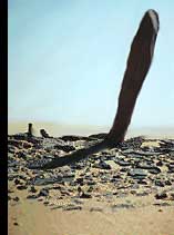
One of the more prominent quartzite sandstone "monoliths" that dot the dried up lake bed, or "playa", that is the setting for the
Nabta Playa prehistoric settlement area in southern Egypt. These sandstone monoliths are believed to perform the same function as the
triptychs at Stonehenge, that of an astronomical calendar. Image from
Discover Magazine.
|
|
Nabta Playa is a recently discovered collection of standing stones and related structures in southern Egypt. Located approximately 70
miles west of
Abu Simbel
in
southern Egypt,
the site was discovered in 1974 by a group of scientists from
Southern Methodist University
led by an anthropology professor by the name of
Fred Wendorf.
Wendorf and his team had been driving from Libya to the Nile Valley, and had stopped to take a break, when they noticed that they were
walking among potsherds and various artifacts. What was at once a curiosity soon turned into a career spanning archaeological odyssey,
the site having become a major focus of his studies ever since.
Wendorf named the area "Nabta Playa" after the arabic word nabta, "little bushes", and playa, a scientific term referring
to temporary, seasonal lakes. Wendorf called it a playa as, though now Nabta is extremely dry and incapable of supporting more than a
minimal amount of life, it once was a seasonal lake, teeming with life. This was due to the fact that, around 10,000 b.c., there had
been a substantial climate change in North Africa that had been brought about by the northward shift of the southern monsoons. As a
result, during the monsoon season, Nabta received around 4-8 inches of rain per year, filling up the playa and causing the area to
spring to life.
As a result of this climatic shift, nomadic cattle herders began to migrate to the area during the rainy season. Nabta saw its first
settlements around 9000 b.c. These nomads were likely much like the modern
Masai
of Kenya, who use the milk and blood of their cattle as nourishment, only killing cattle to commemorate major events such as births,
deaths and marriages. Around 7000 b.c., the Nabtans began to develop larger settlements, dig wells to allow them to stay in the area
year-round, and produce pottery. However, between 6000 and 5000 b.c., drought conditions returned, and for a time, the Nabtans
disappeared.
Around 5000 b.c. new groups of people migrated to the area, people that possessed a much higher degree of social organization
and a coherent religious belief system. It was during this time, by this people, that the major monolithic structures were developed
at Nabta. They quarried large pieces of quartzite limestone, fashioning them into rude monoliths that were around 6 feet high, 4 feet
wide, and 1-2 feet thick. These monoliths were partly buried in the playa and arranged so as to form five megalithic alignments.
One of these alignments forms a north-south axis, and another forms an east-west axis.
Three hundred yards north of the monolithic alignments is a stone calendar circle, much like
Stonehenge
in layout, but on a much smaller scale, being only 12 feet in diameter. The circle is composed of numerous stones, with four pairs of
larger stones outstanding. Also like Stonehenge, the stone circle forms meaningful alignments, with two pairs forming a north-south
alignment, and another two pairs forming an east-west alignment which precisely target the rising and setting points of the sun on the
summer solstice ca. 4500 b.c. Another 300 yards north of the stone circle can be found stone covered tumuli that contain the remains of
ritually buried cattle. These cattle remains, along with other significant monuments in the area which appear to be rough sculptures of
cattle, appear to indicate the existence of a cattle-worship cult among the ancient Nabtans.
The worship of cattle was of course of great importance to the ancient Egyptians, the bull goddess Hathor and the prominent worship of
the Apis bull being important parts of ancient Egyptian religion. Some theorists believe that the prominence of the cattle cult (and of
astronomy)
in Egypt's later periods, may have been an offshoot of the cattle worship of these ancient nomadic peoples.
Nabta Playa is definitely off the beaten path as a tourist destination. However, it is near Abu Simbel, which is a major tourist
attraction second only to the the pyramids and
Sphinx.
Access-Africa.com
offers an Aswan-Cairo tour, starting in southern Egypt near Nabta Playa, so perhaps your guide could be persuaded to swing by the
playa and treat you and your fellow tourists to a part of Egypt's ancient past most visitors never see.
Tour Egypt
also has a comprehensive list of tours and tour guides that may help you make Nabta Playa a significant part of your Egyptian
vacation.
Minnesota State eMuseum: Nabta Playa
de facto: Nabta Playa
Discover Magazine: Egyptian Stonehenge
Comparative Archaeology Web:
Nabta Playa
Wisdom Tools: Nabta Playa
Digital Egypt for Universities:
Nabta Playa
Digital Egypt for Universities:
Nabta Playa Timeline
Tour Egypt: Egypt's Official Tourism Site
TourismNet: Egypt
Five Star Egypt Tourism
Egyptian Tourist Authority
Tour Egypt: Abu Simbel
Map of Egypt
Access-Africa.com: Aswan-Cairo
|
|
|
|

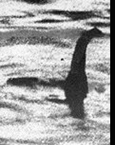 The classic "surgeon's photo" of Nessie, later proven to be a toy submarine with a fake Nessie head strapped to the top
that had been photographed in the shallows of Loch Ness. Though debunked, the image remains as an icon representing the search
for mysterious sea serpents. Image from
Canada.com.
The classic "surgeon's photo" of Nessie, later proven to be a toy submarine with a fake Nessie head strapped to the top
that had been photographed in the shallows of Loch Ness. Though debunked, the image remains as an icon representing the search
for mysterious sea serpents. Image from
Canada.com.
|
|
In last year's series on
Mysterious Sea Serpents
we explored all the major (and most minor) sea serpent and lake monster sightings around the world. Recently, one of the creatures
that we covered in a previous Fragments article,
Chinese Sea Serpent,
has made a prominent reappearance.
Located in the
Jilin province
of northeastern China, near the China/Korea border, is a volcanic lake by the name of Lake Tianchi. For close to a century, sightings
of a large, black, serpentlike creature with a horselike head have made the lake a popular tourist attraction, even inspiring the
formation of a fan club, the "Tianchi Monster Society". However, no pictures have been taken of the creature(s), only eyewitness
accounts.
Two of the more unusual accounts include on in 1903 when, according to local records, a creature resembling a huge buffalo rushed out
of the water, roared loudly, and attacked three people. Fortunately, one of them was armed, shooting the creature six times before it
retreated back into the water. Another account describes the monster's head as not like a horse, but like a human, with large, round
eyes, a protruding mouth, a 4-5 foot long neck, and smooth, gray skin all over its body.
The most recent sighting took place on July 11, 2003, when several eyewitnesses saw a school of "mysterious creatures"
swimming in the lake for close to an hour. The creatures appeared singly, and in groups of as many as 20 at one time. No details
regarding how the creatures appeared were available, unfortunately, as the creatures were 1-2 miles away from the observers,
appearing only as white or black spots in the distance.
Around the same time, a sea serpent sighting of a different kind took place halfway around the world at Loch Ness. There, one
Gerald McSorley, a retired scrap dealer, stumbled and fell into the water along the shoreline, his hand happening upon a strange
object buried just under the surface. Digging out the strange object, he brought it to a museum in Edinburgh to have it examined,
and was given the pleasant news that he had just discovered the fossil vertebra of a plesiosaur.
Though there are many theories as to what the Loch Ness monster is, most believe that it is a plesiosaur that had somehow survived
the destructions that ended the age of the dinosaurs. Critics say, however, that there are not enough fish to support a plesiosaur's
diet, let alone a family of plesiosaurs, which would be necessary in order for the species to continue. However, it is possible that
Loch Ness is connected with other lakes and even the sea via underground tunnels, making Loch Ness more of a vacation spot for
Nessie rather than a permanent home. Other animal species, such as the coelocanth, have survived the destructions of those ages,
so though it is unlikely that plesiosaurs still roam the deeps, it is not impossible.
Other sea serpents and lake monsters have been seen all over the world, throughout human history. From America's
Champ
of Lake Champlain to Canada's
Ogopogo
to literally
dozens of other
sea serpents and lake monsters, sea serpents remain at the top of the list of mankind's enduring objects of fascination.
Jilin province
is located in the northeast region of China, on the border with North Korea. During World War II it served as the "puppet
Manchukuo State" that the Japanese used to administer the conquered regions of China. Other interesting points of interest
besides
Tianchi Lake
and its monster include the Manchukuo Imperial Palace, Jingyue (Clear Moon) Pool, the Changchun Film
Studio, the waterfront city of Jilin, the rimed trees of Jilin, Songhua Lake, and many more beautiful natural and manmade
attractions. For more information on visiting China, check out the
China National Tourism Administration Travel Tips
page, or check out the links below.
Loch Ness is
located in Scotland,
UK, southwest of Inverness. Scotland tends to be
cooler and rainy year-round,
especially in the north, though the area immediately around the loch tends to be generally warmer.
The lake itself
is 23 miles long, one mile wide, and is an average of 700 feet deep, so it tends to vary little in temperature, and the bridges rarely retain
snow.
Click
here
for more information on visiting Loch Ness.
Reuters: China's 'Loch Ness Monster' Resurfaces
Travel China Guide: Tianchi Lake
China National Tourism Association
Travel China Guide
China Travel Service
BeijingTrip.com
Imperial Tours
Canada.com: "Jimmy Hoffa and Nessie: Two Big Clues in One Day"
Travel Scotland
CNN.com: "Chinese Nessie 'Alive and Well'"
Scottish Tourist Board
Gateway to Scotland
Cruise Loch Ness
Loch Ness Guide
TopScot.com: Loch Ness Tour
Castle Cruises Loch Ness
Discover Loch Ness Tour
|
|
Malta
|
Axum
|
Nabta Playa
|
Sea Serpent Sightings
|
Books
|
Video
Editorial
|
Press Releases
|
Book Reviews
|
Fragments
Serpent Mound I
|
Giants I
|
Osiria I
Register
for our new Hall of Records Newsletter!
Questions? Comments? Suggestions? Advertising? Press Releases?
Contact us!


Lonely Planet Malta
Neil Wilson
Whether you're interested in ancient temples or five-day feasts, water sports or basking on beaches, this brand new guide is jam-packed with advice on the best Malta has to offer.
30 detailed city and regional maps
illustrated feature on the Knights of St John
top swimming spots
an insider's guide to Maltese food, from quick pastizzi to quality seafood
helpful language guide and glossary
Click
here
to buy this book.
Malta & Gozo Map
Nils Robert Meyer
Road map with contour lines, ferry routes, and distance markers in kilometres. Features: beaches, airports, anchorages, icons for places of interest, natural features, gardens, and populated areas. Scale: 1:50,000.
Click
here
to buy this book.
Editorial
|
Press Releases
|
Book Reviews
|
Fragments
Serpent Mound I
|
Giants I
|
Osiria I
Register
for our new Hall of Records Newsletter!
Questions? Comments? Suggestions? Advertising? Press Releases?
Contact us!
|
|